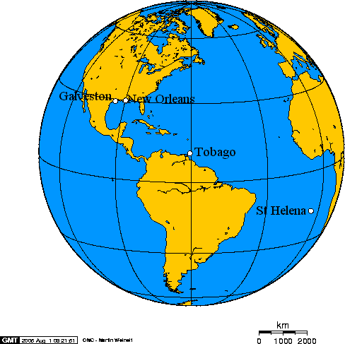
File:Orthographic projection over Tobago - with Galveston - New Orleans - St Helena.png
Orthographic_projection_over_Tobago_-_with_Galveston_-_New_Orleans_-_St_Helena.
I used an tool that was formerly available online to make this map. This online tool used http://gmt.soest.hawaii.edu/ -- presenting a form based front end to the database, and software that were considered free. Thus images prepared with it were free. I chose to put all the images I prepared in the public domain.
The story behind this map is the first chapter in CS Forester's novel Admiral Hornblower in the West Indies. Chronologically, it was the last novel in Foresters famous Horatio Hornblower series. The 2nd through 10th novels had Hornblower rise in seniority and in the size of his commands. In Novels 9 and 10 he was a Commodore, a Captain given temporary command over a squadron, during the 20 year struggle against Napoleon. In the first story in Admiral Hornblower in the West Indies Napoleon Bonaparte has been imprisoned on the very remote Island of St Helena for six years. Hornblower commands the West Indies Squadron, which had been massive, in wartime, but is largely devoted to fighting piracy and regulating the slave trade, so his squadron is no larger, or arguably smaller, than those he had commanded as a senior Captain.
He makes a diplomatic visit to francophone New Orleans, Louisiana, where he learns of a plot by hard-core supporters to free Napoleon. A battalion of Napoleons Imperial Guard had tried to settle in Galveston, Texas, a very isolated portion of Spanish America. Hornblower races to intercept a large American clipper, loaded with the survivors of Napoleon's Imperial Guard from Galveston. Hornblower is faced with several seemingly insurmountable problems. First, he has to determine the best place to intercept the ship carrying Napoleon's soldiers. Second, one he meets them, he has to figure out how to stop them. The American ship, a former slave ship, is much larger than the very small schooner he sails in, and much better armed. Further, his ship has a very small crew, while the American ship carries a battalion of soldiers in addition to her regular crew.
Hornblower decides the best place to intercept the ship is in the Tobago Channel.
Hornblower decides the only way to divert Napoleon's soldiers is to lie -- to rely on the French trusting his word of honour as a Gentleman and an officer -- that Napoleon had died on St Helena.
He meets the French. He tells them Napoleon has died. The French commander asks him if he will confirm Napoleon has died on his word of honor. This Hornblower does, thinking the sacrifice of his word of honour should not keep him from a lie that could save Europe years of warfare.
Hornblower writes a letter of resignation. He figures his career and reputation will be ruined, as soon as the world learns of his lie.
However, shortly after his lie, he learns that Napoleon has in fact died.
Anyhow, the story revolves around the distances between Galveston, New Orleans, Tobago and St Helena. So, when I discovered the map-making tool, this was one of the first maps I made.
File history
Click on a date/time to view the file as it appeared at that time.
| Date/Time | Thumbnail | Dimensions | User | Comment | |
|---|---|---|---|---|---|
| current | 18:14, 15 July 2012 | | 488 × 487 (17 KB) | Geo Swan (Talk | contribs) | Orthographic_projection_over_Tobago_-_with_Galveston_-_New_Orleans_-_St_Helena. I used an tool that was formerly available online to make this map. This online tool used http://gmt.soest.hawaii.edu/ -- presenting a form based front end to the database, a |
- You cannot overwrite this file.
File usage
There are no pages that link to this file.